This has been a year when the U.S. has been hit by one major natural disaster after another, and now two more are on the way. Tropical Storm Isaias is expected to become a Category 2 hurricane before it makes landfall along the Gulf Coast some time on Friday. Meanwhile, the National Oceanic and Atmospheric Administration is now projecting that Hurricane Rachel will make a very sharp right turn toward Southern California. That wasn’t supposed to happen, but apparently conditions have changed. If Rachel makes landfall in the state of California as either a hurricane or a tropical storm, that will be a truly historic event.
This had been such a quiet Atlantic hurricane season, but now that has changed.
Very warm water in the Gulf is providing plenty of fuel for Tropical Storm Isaias, and meteorologists are anticipating that it will make landfall along the Gulf Coast as a Category 2 hurricane about 48 hours from now…
Tropical Storm Isaias is forecast to track northeastward and quickly ramp up to a hurricane while over the central Gulf. Landfall along the central Gulf Coast is expected Friday night as a strong Category 2 storm.
AccuWeather Hurricane Experts say this will become the first hurricane of the 2026 season, making it the latest first hurricane to form in the Atlantic basin in over 100 years.
Waters in the Gulf are well into the 80s F, which will provide plenty of fuel and help Isaias strengthen into a hurricane as it tracks directly toward the Gulf Coast of the United States.
A Category 2 hurricane would certainly cause damage, but it wouldn’t be catastrophic.
However, there is a possibility that Isaias could still strengthen more than expected and become a Category 3 storm…
Because of warm Gulf waters and the wind shear situation, there is potential for Isaias to rapidly strengthen before the end of this week, with the central pressure plummeting and maximum sustained winds correspondingly increasing significantly over a matter of hours.
It is currently predicted to be a Category 2 on the Saffir-Simpson Hurricane Wind Scale when it makes landfall along the U.S. Gulf Coast late Friday night or early Saturday morning. “There is a chance the storm peaks as a Category 3, or major hurricane, while over the central Gulf,” AccuWeather Chief Meteorologist Bernie Rayno warned.
When Hurricane Katrina made landfall on the Gulf Coast on August 29, 2005 it was classified as a Category 3 hurricane.
So let’s watch and see how Isaias develops.
At this stage, it is expected to make landfall somewhere between Biloxi and Panama City…
Isaias is forecast to approach the northern Gulf Coast on Friday, with landfall possible that evening or early Saturday, striking between Biloxi, Mississippi, and Panama City, Florida, putting millions of Americans at risk.
Florida Governor Ron DeSantis has declared a state of emergency for 25 counties ahead of the storm. ‘Floridians should take this time to get disaster plans in place and ensure their hurricane supply kit is stocked,’ DeSantis said in a statement.
I am glad that Governor DeSantis is being proactive.
Hopefully people in the region will take this storm very seriously.
The National Weather Service is warning that Isaias could potentially be life-threatening…
The NWS warned flooding could enter homes, cut off roads and evacuation routes, and force emergency rescues.
Residents were urged to assemble disaster supplies, identify evacuation routes and leave if local authorities order an evacuation.
‘Failure to heed evacuation orders may result in the loss of your life,’ the weather service said.
Meanwhile, a hurricane in the Pacific is also making big news.
When I saw the latest forecast for Hurricane Rachel from the NOAA, I could hardly believe it.
It is now expected to make a very tight right turn which will put it on a path directly toward Southern California…
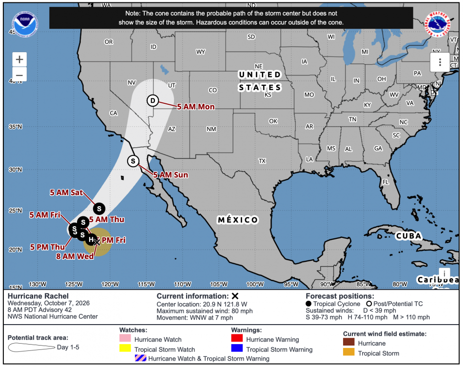
Hurricanes are not really supposed to move like that.
But we are being told that this one will.
According to the New York Post, it is being anticipated that it will make landfall approximately 100 miles south of San Diego, but there is also a possibility that “the path could shift as far north as Orange County”…
Hurricane Rachel has taken a sharp turn toward Southern California and forecasters say it could arrive early Sunday as a weaker, post-tropical storm.
The current forecast shows it coming ashore about 100 miles south of San Diego, but the path could shift as far north as Orange County.
Residents in Southern California and the desert communities should start watching for updates, forecasters said.
Wow.
Under normal conditions, hurricanes and tropical storms fizzle out before they reach California because the water along the coast is so cool.
No hurricane has ever made landfall in the entire recorded history of the state, and the last time a tropical storm made landfall in the state was in 1939.
But this year is far from normal.
A Super El Niño has thrown weather patterns in the Pacific completely out of whack…
“Godzilla.” “Super.” “Very strong.”
There’s no shortage of superlatives to describe the El Niño pattern brewing in the tropical Pacific Ocean, with grave consequences expected in many corners of the world.
So far, data continues to back up the hype.
Sea surface temperatures have spiked to record levels in the tropical Pacific this fall, a sign that the pattern continues to strengthen. In the region where the El Niño trend is typically measured, temperatures are 6.1 degrees Fahrenheit higher than normal.
We have seen hurricane after hurricane develop in the eastern Pacific in 2026.
That is very unusual.
The Super El Niño has also brought an absolutely colossal “Kelvin wave” to the west coast…
Something enormous has been moving quietly up the Pacific toward Southern California.
Now, it’s here.
An El Niño-fueled coastally trapped Kelvin wave is arriving along the Southern California coastline, potentially raising background sea levels another 6 to 12 inches for weeks or even months. Unlike a normal swell, there’s no giant wave face approaching shore. It’s essentially an enormous, slow-moving bulge in the ocean hundreds of miles across.
This “Kelvin wave” started arriving in Southern California just in time for Hurricane Rachel.
Right now, ocean temperatures along the coast in Southern California are “roughly 7 to 8 degrees above average”…
Ocean temperatures off Southern California are also roughly 7 to 8 degrees above average, with record warmth extending from central Baja into the region.
“It’s an important part of the development and evolution of El Niño,” explained Dr. Michael Jacox, a research oceanographer at the NOAA. “You can see the link from the tropical ocean all the way to the West Coast.”
Hurricanes fizzle out in cool water, but they absolutely love warm water.
The fact that the water along the California coast is far warmer than usual at the moment is perfect for Hurricane Rachel.
That doesn’t mean that Hurricane Rachel will actually make landfall in California or that it will be a powerful storm if it does.
In fact, at this stage most meteorologists do not think that Rachel will be a powerful storm wherever it ultimately makes landfall.
But so much could still change over the next few days.
There is a tremendous amount of very warm water out there, and under the right conditions Rachel could potentially become much stronger.
I don’t know exactly what is about to happen, but without a doubt this story just got a whole lot more interesting.
Michael’s new book entitled “10 Prophetic Events That Are Coming Next” is available in paperback and for the Kindle on Amazon.com, and you can subscribe to his Substack newsletter at michaeltsnyder.substack.com.

About the Author: Michael Snyder’s new book entitled “10 Prophetic Events That Are Coming Next” is available in paperback and for the Kindle on Amazon.com. He has also written nine other books that are available on Amazon.com including “Chaos”, “End Times”, “7 Year Apocalypse”, “Lost Prophecies Of The Future Of America”, “The Beginning Of The End”, and “Living A Life That Really Matters”. When you purchase any of Michael’s books you help to support the work that he is doing. You can also get his articles by email as soon as he publishes them by subscribing to his Substack newsletter. Michael has published thousands of articles on The Economic Collapse Blog, End Of The American Dream and The Most Important News, and he always freely and happily allows others to republish those articles on their own websites. These are such troubled times, and people need hope. John 3:16 tells us about the hope that God has given us through Jesus Christ: “For God so loved the world, that he gave his only begotten Son, that whosoever believeth in him should not perish, but have everlasting life.” If you have not already done so, we strongly urge you to invite Jesus Christ to be your Lord and Savior today.